


| | | 4.5 Future perspectives |
Up to 90% of the total flow in a river, is derived from the first and second order streams, also termed headwaters. The control of river-water quality and subsequent retention in these headwaters could therefore be seen as a priority. In addition, once the river water is "contaminated" there is very little possibility of the in-stream nutrient retention processes operating to control river-water quality further downstream, at least when lakes and other impoundments are absent. When it comes to possible abatement strategies one must distinguish between measures at source and measures at transport. Wetlands and buffer zones, e.g., riparian strips along agricultural fields or streams, may be regarded as an intermediate between measure at source and measure at transport.
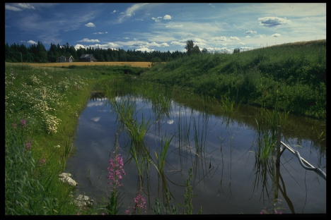
Wetlands is a lumped concept that includes bogs, mires, marshes, floating meadows, and ponds. There has been a great interest in constructed wetlands for wastewater treatment and for reduction of non-point-source pollution. However, the influence of wetlands on natural North European condition has been questioned, as high hydraulic loads result in short residence time and most of the transport occur in late autumn and early spring when biochemical activity is low. In one river basin in southeastern Sweden, it was estimated by model calculations that conversion of 1% of the basin into wetlands would reduce the nitrogen transport by 10-16% and that more than 5% conversion to wetlands is required to reduce the transport by 50% [20]. It is generally accepted that small wetlands remove less nitrogen than lakes due to the lower water residence times. Small constructed wetlands (CWs) in first and second order are widely used in Sweden and Denmark to mitigate fluxes of soil particles and nutrients from agricultural watersheds. In Norway, Braskerud [35] found a N and P-retention of 3-15% and 20-44% in four CWs. The high hydraulic loads and low temperatures explained the low N-removal. In natural wetlands in the landscape, studies have shown that they may be a source rather than a sink. Grimvall & Stålnacke [200] and Arheimer [20] showed that wetlands (i.e. mires and peat bogs, respectively) in S Sweden delivered N, and Lidén et al [288] showed similar results for the wetlands in the Kasari River in Estonia.
It is generally accepted and uncontroversial that buffer zones has large potential to control water pollutants due to sedimentation, plant uptake, and retention in soil and microbial processes. On the other hand, the heterogeneity in terms of soils, biogeochemistry and water pathways are complicated and the understanding of the mechanisms controlling buffer zones are less known. Moreover, results on actual retention potential are controversial since both low and high retention is reported in literature.
Snowmelt runoff can also hamper the retention effect in buffer zones and wetlands, due to its considerable amount combined with low soil and water temperature leading to increased risk of low uptake by vegetation or algae and low denitrification. Information regarding the fate of N in buffer zones during such circumstances are limited, even though recent studies has shown that retention can be high in wetlands and in buffer strips exposed to surface runoff.
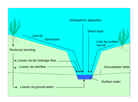
Furthermore, retention in buffer strips and wetlands may also be limited by (i) the organic carbon availability, (ii) soil moisture content, (iii) the residence time for groundwater or surface water and (iv) hydrological routing and pathways hydrological routing and pathways. The latter is one of the key issues to determine, e.g. the hydrological flow-path through the buffer zone, since surface water always take the shortest and easiest route even in flat landscapes. And in case lateral flow dominate, i.e passage via tile drains, groundwater or interflow (Figure 9) wetlands and buffer strips may be less effective. It is also important to distinguish between retention due to vegetation uptake (storage) and denitrification (bacterial transport and gaseous loss processes). Haycock et al., [216] indicated that denitrification is the dominant retention process in buffer zones during the dormant season when soil moisture content is high, while N uptake by vegetation dominates during the summer and growing season.
To conclude, the establishment of wetlands and buffer zones next to or in streams and rivers does not guarantee high nutrient removal. Construction of riparian buffer zones is primarily a question of setting aside land which in turn is a political and economical issue, e.g. in terms of political demand for food production, and less an ecological issue. It is generally accepted that changes in management practices rarely lead to rapid large-scale changes in nutrient losses to water recipients. One important reason is the buffering capacity of agricultural soils and the retention capacity of the agricultural landscape. Another reason is that management practices usually do not change very fast, although they did in the Baltic states. After all, nutrient losses are unavoidable processes, and can be influenced by field operations only to a certain extent. When the feasibility of reducing the input of nutrients to seas is discussed, the retention of nitrogen and phosphorus in the drainage area must also be taken into account. For example, considerable retention may - besides the surface waters itself- aslo take place in the soil column and in groundwater aquifers. A short-term measure might be to establish grassland/pasture or plant marketable industrial crops to reduce the nutrient losses by leaching of mineralised N or P in surface runoff from unprotected soils. A long-term measure might be to plant forest (or energy forest).
| | | 4.5 Future perspectives |