

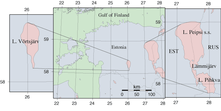
| | 21.1 Introduction |
Lake Peipsi (3,555 km2, mean depth 7.1m) is one of the most important lakes in Europe and has the fourth largest surface area after Lakes Ladoga, Onega, and Vänern. Located on the Estonian-Russian border, Lake Peipsi is a transboundary waterbody and the largest international lake in Europe. The volume of water in Lake Peipsi is 25 km3 at the long-term mean water level (30.00m above sea level) and the mean residence time of water is about 2 years [245]. The River Narva contains the outflow of Lake Peipsi and runs into the Gulf of Finland. Lake Võrtsjärv (270 km2, mean depth 2.8m) is the largest lake belonging entirely to Estonia (Figure 1). The watershed of Lake Võrtsjärv (3,104 km2) lies within Lake Peipsi catchment (47,800 km2). Regular investigation of these two large, shallow, nonstratified lakes began in the 1960s. To date, over 35-year time series on water chemistry and biology have been collected.
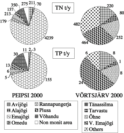
Riverine transport is the most common pathway for nutrient input into both lakes. The four rivers Väike Emajõgi, Õhne, Tarvastu, and Tänassilma contribute 70-75% of the water inflow into Lake Võrtsjärv and 80-85% of the total load of substances. In Lake Peipsi, the majority of phosphorous and nitrogen compounds (>80%) are carried into the lake by the rivers Velikaya and Emajõgi (outflow from Lake Võrtsjärv), the first carrying biologically treated sewage from the Russian town of Pskov (ca. 200,000 inhabitants) and the latter transporting wastewater from the Estonian town of Tartu (ca. 100,000 inhabitants). A water treatment plant has been in operation in Tartu since the end of 1998; prior to its installation, water from Tartu was untreated. The River Emajõgi contributes approximately 70% of the total nitrogen (TN) and total phosphorus (TP) loading into Lake Peipsi from Estonian territory (Figure 2). The Russian River Velikaya contributes about 65% of all nutrient loading into Lake Peipsi [439] and about 85% of that comes from Russian territory.
Lake Peipsi consists of three parts: the largest northern part, Lake Peipsi sensu stricto, 2,611 km2, mean depth of 8.4m and maximum depth of 12.9m; the southern part, Lake Pihkva, with an area of 708 km2 and mean depth of 3.8m; and the narrow river-shaped Lake Lämmijärv with an area of 236 km2 and mean depth of 2.6m that connects Lake Peipsi with Lake Pihkva,. The entire catchment area (47,800 km2) involves parts of Estonian, Russian, and Latvian territories. Lakes Peipsi and Võrtsjärv are unstratified and eutrophic, Lake Lämmijärv has some dystrophic features, while the trophic status of Lake Pihkva is the highest reaching even hypertrophic level (Table 1).
| Units | L. Peipsi mean | L. Pihkva | L. Lämmijärv | L. Peipsi s.s. | L. Võrtsjärv | |
| TP | mg P m-3 | 42 | 63 | 53 | 35 | 54 |
| TN | mg N l-1 | 0.77 | 1.01 | 0.9 | 0.68 | 1.6 |
| Chlorophyll a | mg m-3 | 18 | 26 | 25 | 14 | 24 |
| Secchi depth | m | 1.8 | 1.3 | 1.4 | 1.8 | 1 |
| | 21.1 Introduction |