


| | | 16.2 Assessment of the ecological status |
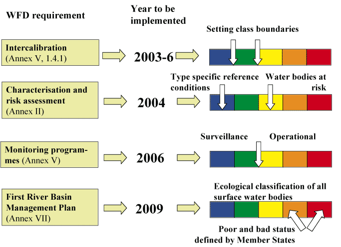
The requirement of the detailed assessment of the ecological status of the water bodies in the river basins is the basis for the protection of the aquatic ecosystems in the WFD. There are several articles which set the timetable and steps for the assessment process and the details of the tasks required to be undertaken are described in the detail in the Annexes of the WFD for different surface water categories (Table 1). The first task is to complete a detailed characterization of all surface waters in each EU Member State (Step 1).
| WFD | WFD | Annex | Tasks relevant for the | Year to be | |
| Requirement | Article | No. | ecological status | completed | |
| No. | assessment | ||||
|
1 | Characterisation | 5 | III | Geomorphological-physical | 2004 |
| of | types for all surface waters | ||||
| surface | and type-specific reference conditions | ||||
| waters | for biological quality elements | ||||
| 2 | Setting the environmental | 4 | V | Identification of criteria | 2006 |
| objectives for protection | for high, good, and moderate | ||||
| and restoration of all | according to Tables 1.2.1-5. | ||||
| waters -- definition and | Harmonization of the | ||||
| harmonisation of concept | ecological quality classification | ||||
| `good ecological quality' | systems between countries | ||||
| (1.4.) (`Intercalibration exercise') | |||||
| 3 | WFD compatible | 8 | V | Establishment of the | 2006 |
| monitoring programmes | surveillance, operational and | ||||
| established and | investigative monitoring | ||||
| operational | programmes | ||||
| 4 | River Basin management | 13 | VII | Classification of all surface | 2009 |
| plans ready and published | water bodies using Ecological | ||||
| Quality Ratios based on | |||||
| biological quality elements |
The first step -- characterisation of surface waters -- requires an assignment of all rivers, lakes, transitional and coastal waters into geographic units: river basin districts and further to river basins [12]. This includes identification of surface water bodies, grouping them into types, and the definition of biological and chemical reference conditions (natural baseline) for those types. Water bodies should be discrete and significant sub-units with uniform typology and quality status. Water bodies as such will be the basic unit for reporting and assessing compliance with the directive's environmental objectives [13]. Concurrently, the significant anthropogenic pressures must be identified, and their impacts on the surface water status must be analysed [17].
The main purpose of typology is to enable type specific reference conditions to be defined which in turn is used as the anchor of the classification system [14]. Water body types should be characterised based on geographical, geological, morphological and physical factors. In ecological quality assessment, the purpose of typology is to group sites where the biology is similar in the natural baseline conditions, to enable the detection of the effects of human disturbance. This is only meaningful when the variability of the biological parameters is smaller within types than between types, depending not only on the typology, but also on the biological parameters chosen. The typology should therefore identify physically and morphologically distinct water body groups enabling comparison of `like with like' [14][16]. This means, for instance, that naturally eutrophic lakes have different reference conditions than oligotrophic lakes, resulting in different scales and requirements for good ecological quality for these different lake types. The WFD allows two different approaches for typology Đ `System A' and `System B'. The difference is that System A prescribes how water bodies shall be characterised spatially (ecoregions) and with respect to specific altitude, size and depth intervals, and that System B, besides lacking this prescription, permits the use of additional factors [14].
Validation of different types by evaluating the within-type variability of biological communities requires good quality biological monitoring data from unimpacted sites, which is currently not available from many Member States [14]. For many types, most of the water bodies are significantly impacted by human pressures, and therefore it will be difficult to distinguish statistically between the impact of pressures and the type-specific factors that shape the aquatic biological communities.
In the WFD implementation, typology is needed for different purposes. For reporting and intercalibration a typology should ideally be simple and applicable all over Europe for all quality elements. On the other hand, defining reference conditions may require complicated typologies. Different regions and different quality elements may also require different typologies. Typology systems should have a certain level of flexibility, with the possibility to adapt and refine them when more and better biological monitoring data become available.
Two main approaches can be taken in the determination of the surface water body types: 1) types are defined from knowledge of how physical drivers determine biological communities (`a priori approach'), and 2) types are distinguished by analysing survey data from reference sites (`a posteriori' approach) (Table 1). System A of the WFD is an example of an `a priori' example; system B typologies can be defined using both approaches.
|
`a priori' typologies | `a posteriori' typologies |
| Should be based on knowledge of how biology is | Based on physical and biological monitoring |
| determined by geography/physical conditions | data from reference sites |
| Few data needed to define typology | Typology depends on available data |
| (quality elements, parameters, from | |
| which region), and on quality of data | |
| Types not necessarily biologically meaningful | Types biologically meaningful |
| because of incomplete knowledge -- need for | |
| validation using targeted field sampling | |
| Reference conditions can be determined | Reference conditions implicit |
| by different approaches (expert judgement, spatial, | |
| historical/ paleoreconstruction,modelling) |
Only very few countries have established advanced `a posteriori' systems for classification and typology. One of the main reasons preventing the development of such systems is that it requires the availability of high-quality data from many water bodies, sampled in a standardised way. The UK RIVPACS approach [499], developed to predict reference macroinvertebrate communities in rivers, is a very good example. The potential of this approach is demonstrated in Swedish studies, where RIVPACS-type models (SWEPACS) have been successfully developed for both lake (littoral) and stream (riffle) macroinvertebrate communities [253]. The European research projects STAR3 and FAME4 are extending such an approach over a larger geographical area, including wider range of river types, and more biological quality elements collected using harmonised methods. Furthermore, a European research project, CHARM5 is developing harmonised typology for the coastal Baltic Sea first starting from `a priory' typology that will validated using existing biological monitoring data from Baltic Sea countries.
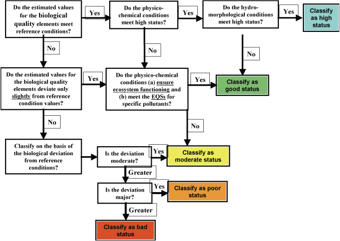
The Directive stipulates that the ecological quality classification "... shall be represented by lower of the values for biological and physico-chemical monitoring results for the relevant quality elements..." (WFD, Annex V, 1.4.2). Furthermore it is required that the ecological quality of water bodies should be classified into five quality classes (high, good, moderate, poor, and bad) using Ecological Quality Ratio (EQR), defined as the ratio between reference and observed values of the relevant biological quality elements.
The relevant biological quality elements for the different water body categories are specified in Table 2.
|
Quality element | Rivers | Lakes | Transitional waters | Coastal waters |
| Phytoplankton | 1, 2, 3*, 4 | 1, 2, 3, 4 | 1, 2, 3, 4 | 1, 2, 3, 4 |
| Aquatic flora | 1, 2 | 1, 2 | 1**, 2 | 1**, 2, 6 |
| Benthic invertebrates | 1, 2, 5, 6 | 1, 2, 5, 6 | 1, 2, 5, 6 | 1, 2, 5, 6 |
| Fish | 1, 2, 6, 7 | 1, 2, 6, 7 | 1, 2 | - |
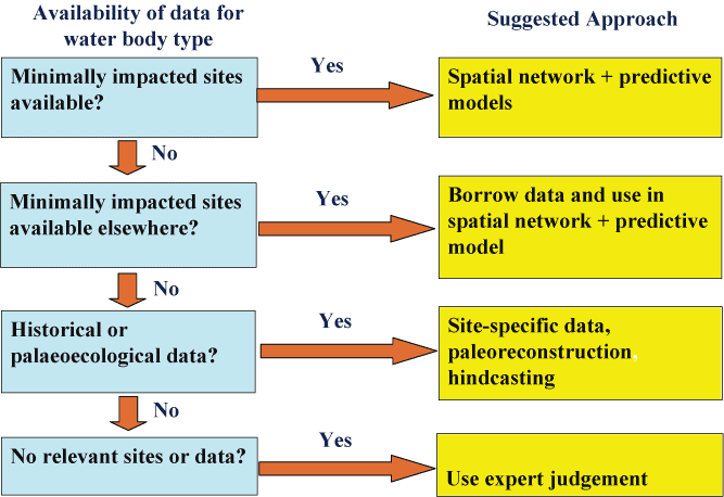
Reference conditions can either be spatially based, i.e. defined by collecting biological information from water bodies which are (almost) in natural base-line conditions (sites with minor anthropogenic impacts), or derived by modelling, or by combination of those. If reference conditions are to be defined using modelling, either predictive models or hind-casting using historical, palaeolimnological, and other available data can be applied (Anonymous, 2003d). In many countries there may be no reference sites available or data are insufficient to carry out statistical analysis or validate models. In that case, expert opinion may be the only possibility to define reference conditions. Also the establishment of common networks of reference sites could help in setting type specific reference conditions in a comparable way between different countries.
A stepwise procedure for establishing reference conditions is suggested (Figure 3). This would depend on the availability of data form different water bodies types. If there is data available or pressure criteria [14] can be used to select minimally impacted sites for different types, suggested approach would be to establish a network of reference sites, where data for biological quality indicators in reference conditions can be obtained. In combination to that also predictive models can be validated and used to establish reference values for the parameters that represent the different biological quality elements, and apply these models to sites where biological data may be scarce or not available for all quality elements. In some cases collaboration across national borders is required since natural baseline sites for a given types may be found in other countries. If there are no sites with minor anthropogenic impacts, historical monitoring data or paleoecological reconstruction methods should be used to for reconstruction of reference conditions before the time period of significant human impact (Figure 3). Expert judgement may be needed to evaluate when the human impact started to increase, and which period would represent conditions with a minor impact. Finally, if no site nor any data is available for a given type, expert judgement remains the only alternative.
A case study for the establishment of reference conditions for lake phosphorus concentrations was carried out for Swedish lakes using combination of different approaches (R. Johnson, pers. comment). The results indicated that variability in the established reference phosphorus concentrations may be large depending on the method. A Danish study on setting the reference conditions for coastal Eelgrass (Zostera marina) populations comparing the present and past depth distribution of Eelgrass, indicated that the reference conditions based on historical data had to be established site specifically, since the variability within the type specific reference conditions was too large which did not allow reliable calculation of EQR values [271].
Schernewski and Neumann (in press) compiled estimations of pre-industrial riverine and atmospheric nutrient loadings to the Baltic Sea using long-term monitoring data from rivers and various literature sources. These loadings were used as input to an integrated biogeochemical Đ physical ecosystem model to obtain reference nutrient and chlorophyll concentrations for different coastal areas of the Baltic, as well as the central Baltic Sea. They estimated that in the central Baltic Proper the average annual chlorophyll concentrations were reduced 20-40% from those of 1980's, and in the eastern coastal Baltic even 60% reduction of chlorophyll was obtained in the model calculations. However, one has to treat model calculations with caution, especially if the models are validated based on present day conditions and data can be used to simulate nutrient dynamics more than 100 years ago when conditions may have been quite different. Alternatively Andersen et al. [6] have used palaeoecological approach to determine pre-industrial nitrogen concentrations in some coastal locations in the Baltic. Their approach was based on analysis of fossils diatom assemblages from sediment cores sampled, and using calibrated transfer functions to evaluate formed nitrogen concentrations in those locations. Although these models are useful tools for estimation of past nutrient concentrations, still reference conditions for the biological quality elements will also be required, in order to obtain EQR-values for the coastal types
In the WFD, high ecological status is defined as `slight' or `minor' deviation from the reference conditions of a surface water body type, while the good status is defined as `small' deviation. The CIS guidance documents suggest that due to the variability of type specific reference conditions, it will be more practical to consider that high status is equal to reference conditions [14][16]. In order to be able to set the quality classes and their borders, more detailed criteria are needed. There should be also an agreement of how the quality borders are set statistically [14]. The WFD requires a `one out - all out' approach for classification, potentially using a high number of quality elements, and the status of a site should be determined by the lowest value of the quality elements used. Various quality elements have different sensitivity to pressures, thus they may reflect the impacts of pressures differently. Because all quality elements have a certain error (that can be very high), the potential of misclassification is amplified by the number of quality elements included in the `one out - all out' system. A recent guidance prepared by the WFD CIS working group on Ecological Status provides recommendations how different quality elements could be grouped in the process of classification depending for which pressures those would be sensitive for [19].
At the moment there is no scientific basis for setting the class boundaries to be corresponding to the normative definitions in Annex V (1.2.1-5). In `good' status the biological quality elements should indicate only `slight' deviation from reference conditions, and the hydromorphological, physico-chemical, and chemical quality elements should ensure ecosystem functioning [14]. However, it is not clear how the ecosystem functioning in good status should be defined. The functional diversity of the ecosystemŐs trophic structure may display high variability of response [262][81] when subjected to human impacts such as nutrient loading [498].
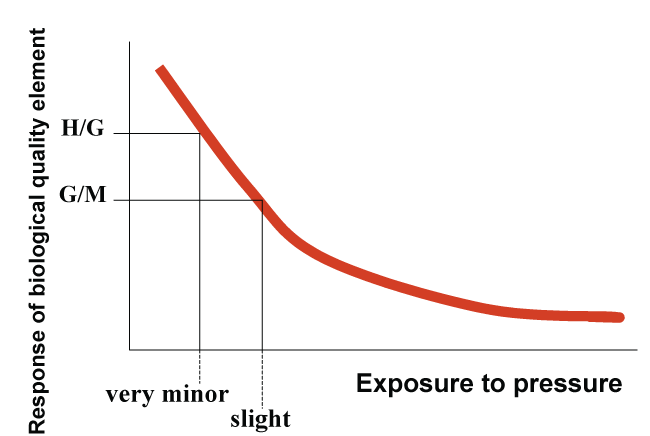
One possible approach would be to establish functional relationships (i.e. dose-response models) between pressures and biological quality element (or parameters) which are sensitive for those pressures and specific for surface water categories and types. The quantitative changes of the parameter values could then be matched with the normative definitions in the Annex V of the WFD, in order to enable identification of `very minor' and `slight' changes from the reference conditions, and further setting of the quantitative values for the class boundaries `high-good' and `good-moderate' (Figure 4). However, in order to verify that in good ecological status physico-chemical conditions should enable `ecosystem functioning' conceptual understanding of the linkages between ecosystem components as response to major pressures would be required. This is also in line with the requirement of the `one-out-all-out' principle where the lowest of the quality elements will determine the final classification status of the water body. Ultimately impacts on one trophic level will have consequences also to other components of the ecosystem and therefore all biological quality elements should be considered (if the natural variability is small enough to allow detection of impacts).
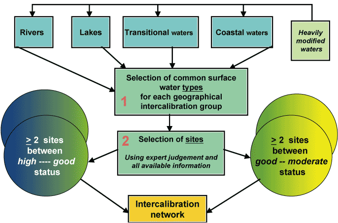
In order to ensure comparability of the classification results based on the Ecological Quality Ratio (EQR) scales between the different EU countries and to obtain comparable criteria for the interpretation of the normative definitions for different quality classes (i.e. there needs to be a common understanding of the good ecological status of surface waters) all over EU, harmonisation of the ecological classification systems is needed. To achieve this, the directive requires an Ôintercalibration exerciseŐ, that will be completed by the end of 2006. Prior to this an intercalibration network consisting of selected intercalibration sites needs to be established by the end of 2004 [18].
Member States and Accessions Countries have agreed on common intercalibration types for the network, as well as pressures and quality elements that will be the focus for the intercalibration. Each of these common types is shared by a number of countries forming geographical intercalibration group (GIG). Currently (November 2003) there are sixteen (16) GIGs identified for both inland and coastal waters in the draft register forming the intercalibration network (Table 4).
|
GIG | Number of | Number of | Number | |
| Countries | Types | of sites | ||
| RAL | Alpine rivers | 6 | 2 | 104 |
| RBA | Baltic rivers | 4 | 4 | 19 |
| RCE | Central rivers | 16 | 6 | 225 |
| REC | Eastern continental rivers | 9 | n.d. | 5 |
| RME | Mediterranean rivers | 7 | 5 | 104 |
| RNO | Northern rivers | 5 | 8 | 130 |
| LAL | Alpine lakes | 8 | 8 | 38 |
| LAT | Atlantic lakes | 4 | 3 | 27 |
| LBA | Baltic lakes | 4 | 5 | 36 |
| LCE | Central lakes | 10 | 8 | 41 |
| LEC | Eastern continental lakes | 9 | n.d. | 1 |
| LME | Mediterranean lakes | 7 | 9 | 40 |
| LNO | Northern lakes | 5 | 7 | 90 |
| CBA | Baltic Sea | 8 | 10 | 19 |
| CME | Mediterranea Sea | 6 | 7 | 5 |
| CNE | North-East Atlantic | 11 | 10 | 76 |
| TOTAL | 92 | 915 |
RBA RNO RCE RAL RME REC LBA LNO LAT LCE LAL LME LEC CBA CNE CME
Estonia 3 14 0
Latvia 4 6 0
Lithuania 7 4 1
Poland 5 8 12 10 4
Finland 1 2 5
Sweden 16 0 21 7 3
Norway 74 46 1
UK 31 42 12 12 4 36
Ireland 8 17 9 15 16
Denmark 14 0 0 0
Netherlands 17 7 8
Belgium 24 5 1
Luxemburg 0 0
Germany 25 9 11 13 2 9
France 33 21 8 4 7 0 2 0
Spain 10 7 45 0 1 21 0 0
Italy 0 0 0 0 0 0
Slovenia 4 0 0 1 0 1
Austria 10 20 4 15 0
Czech Republic 21 0 0 0
Slovakia 0 0 0 0 0
Greece 10 0 0 0 3
Portugal 35 0 15 0
Cyprus 5 4 1
Hungary 0 0
Bulgaria 0 0
Romania 1 1 1
Malta 0 0
TOTAL 19 130 225 104 104 5 36 90 27 41 38 40 1 19 76 5
|
Characterisation of the common lake type | FI | IE | NO | SE | UK |
| 1. Lowland, shallow, siliceous, moderate alkalinity, large | X | X | X | X | X |
| 2. Lowland, shallow, siliceous, low alkalinity, large. | X | X | X | X | X |
| 3. Lowland, shallow, peat, large | X | X | X | ||
| 4. Boreal, large, very shallow, siliceous, moderate alkalinity | X | X | X | ||
| 5. Boreal, shallow, siliceous, low alkalinity, large | X | X | X | X | |
| 6. Boreal, shallow, peat, large | X | X | X | ||
| 7. Highland, shallow, siliceous, low alkalinity, large | X | X | X |
The aim of the intercalibration exercise is to set EQR values for the relevant class boundaries (high-good, good-moderate). The selection of the intercalibration sites will reflect the Member StatesŐ perception of the quality classes. Since the WFD compatible monitoring program are not yet operational during the intercalibration process [15], the site selection and the exercise have to base on existing data. Since current biological monitoring data is scarce, or even non-existing in many EU countries, intercalibration exercise has to be focused on biological quality elements and assessment methods that have been most commonly used in Europe to assess impacts of most widespread pressures [18]. This implies that the assessment methods for the `ecological status' will not be compared and harmonized as whole, but merely `eutrophic status' or `organic pollution status' depending on availability of data and methods for the intercalibration exercise.
Although not required by the WFD, revision of the intercalibration network and repetition of the intercalibration exercise would be useful also after 2006 when WFD compatible monitoring data begins to be available. This would enable setting revised management targets for the next river basin management cycle (revision of the characteristics and reference conditions of water body types is required after every six years by the Article 5 of the WFD), and finally intercalibration of the ecological status of surface waters as a whole.
| | | 16.2 Assessment of the ecological status |